
A chance to learn a little bit about each of the states in the nation.
The Great Seal of the State of Arizona is ringed by the words “Great Seal of the State of Arizona” on the top, and 1912, the year of Arizona’s statehood. In the background is a range of mountains with the sun rising behind the peaks. At the right side of the mountains is a water reservoir and a dam, with irrigated fields and orchards. Cattle are grazing on the right, and a quartz mill and a miner (George Warren) with a pick and shovel are on the left.The state seal is representative of the foundational elements of the Arizona economy: cattle, cotton, copper, citrus, and climate, which are all visible on the seal. The "Five Cs", as they are commonly known, appear as follows: Cattle are represented by the cow at approximately 5 o'clock. Citrus is represented by the irrigated orchard slightly left of the middle. Cotton is represented by the irrigated fields slightly right of the midline. Copper is represented by the miner on the left. Climate, as expressed and exported in the flora and fauna, is represented by the sun and rainclouds.
Source: Wikipedia
Arizona- "The Grand Canyon State"

- Arizona entered the union as the 48th state on February 14, 1912
- Arizona's constitution was adopted in 1911
- Capital- Phoenix
- State Motto- "Ditat Deus" - "God Enriches"
- State Flower- Saguaro cactus
- Gemstone- Turquois
- State bird- Cactus wren
- State Tree- Palo verde
- Mammal- Ringtail
- Butterfly- Two-tailed swallowtail
- Agriculture strengths- Cattle, calves, dairy products and cotton
- Manufacturing- Electrical, communications, aeronautical items
- Leading producer of copper, providing over half the country's output
- U.S. Native American population is one of the largest with 14 tribes represented on 20 reservations.
- Arizona history is rich in legends of America's Old West. It was here that the great Indian chiefs Geronimo and Cochise led their people against the frontiersmen. Tombstone, Ariz., was the site of the West's most famous shoot-out—the gunfight at the O.K. Corral.

 Please visit Arizona History site for more info
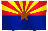
The flag of the state of Arizona consists of 13 rays of red and weld-yellow on the top half, the colors of the flag of Spain, representing the 13 original states. The red and yellow also symbolize Arizona's picturesque sunsets. The copper star represents the copper mining industry in Arizona. The rest of the flag is colored blue, representing liberty.
How Arizona Got Its Name:
"There are two sides in the argument over the origin of Arizona’s name. One side says that the name comes from the Basque aritz onak (“good oak”) and was applied to the territory because the oak trees reminded the Basque settlers in the area of their homeland. The other side says that the name comes from the Spanish Arizonac, which was derived from the O’odham (the language of the native Pima people) word ali ṣona-g (“having a little spring”), which might refer to actual springs or a site near rich veins of silver discovered in 1736. For what it’s worth, official Arizona state historian Marshall Trimble had supported the latter explanation but for now favors the former."
Info from the Mental Floss Magazine Blog
Arizona History and How It Got Its Shape |

"The eastern border was created in 1863 to divide it from New Mexico. The first territory of Arizona was actually divided horizontally instead of vertically. In 1862, during the Civil War, an unofficial gathering of citizens in the New Mexico territory voted that the southern half of the territory was joining the Confederacy. At that time, the population in the southern territory was predominantly Anglo as opposed to Hispanic. A Confederate regiment soon arrived to defend the territory, followed by Union forces that put an end to Arizona's secession."

One year after the Civil War, steamboat navigation was opened on the Colorado River from the Gulf of California as far north as Callville, AZ. Immediately after steamboats came to Callville, Congress lopped off 18,000 square miles of the northwestern part of Arizona and added to the southern end of Nevada. This land transfer resulted in greater land equality between Arizona and New Mexico. Arizona's western border now became the Colorado River to the point where it crossed the same longitude as the line between Nevada and Utah. From there, the western border followed the line due north to its northern border."
"Arizona's northern border first emerged as a boundary in the Compromise of 1850, legislation that established the boundary between Texas and the New Mexico territory. By establishing the northern border of the New Mexico territory at 37º, Congress could then create a tier of Rocky Mountain states, each having four degrees of height, between the New Mexico territory and the Canadian border. Indeed, Colorado, Wyoming and Montana are all four degrees tall."
How the States Got Their Shapes by Mark Stein ©2008, pages 21-26
Arizona and WWII
Arizona served a variety of roles in World War II. The Army Air Forces opened up air fields all over the state: Kingman, Thunderbird I, Thunderbird II, Falcon, Yuma, Marana, Claiborne (Wickenburg), Williams, Luke, Ryan, Davis-Monthan, Douglas, Ajo, and Gila Bend.
President Roosevelt signed Executive Order 9066 on February 19, 1942. As a result, Japanese Americans were ordered to internment camps in several locations across the United States. In Arizona, Canal Camp and Butte Camp made up the Gila River Internment Camp. Another camp located near the Colorado River was Poston.
Above excerpts from an incredibly interesting site including some great pictures called WWII Arizona Army Airfields, Aircraft Wrecks and Internment Camps

"USS Arizona (BB-39) was moored inboard of the repair ship Vestal (AR-4) when the Japanese struck Pearl Harbor. Early reports claimed that she had been hit by one torpedo in the first part of the action. However, this appears not to have been the case, and the destruction of the ship was entirely the work of Japanese horizontal bombers, which struck her with several bombs. Some of these caused damage to her after and midships areas, but their effects were minor compared with what resulted from one that penetrated beside her forward turrets."

"The massive explosion that followed has never been fully explained, since the bomb apparently did not pierce Arizona's armored deck, which protected her magazines. Many qualified authorities have blamed powder storage outside of the magazines as the cause, but this is conjectural and probably will always remain so. In any case, the battleship was utterly devastated from in front of her first turret back into her machinery spaces. Her sides were blown out and the turrets, conning tower, and much of the superstructure dropped several feet into her wrecked hull. This tipped her foremast forward, giving the wreck its distinctive appearance."
"Blazing furiously, Arizona quickly settled to the bottom of Pearl Harbor, a total loss. She burned for more than two days and was subsequently the subject of only partial salvage. Over 1100 of her crew were killed, including Rear Admiral Isaac C. Kidd, Commander Battleship Division One, and the ship's Commanding Officer, Captain Franklin Van Valkenburgh. Their sacrifice, and that of the other men lost at Pearl Harbor, is now permanently memorialized by the USS Arizona Memorial, erected over her sunken hull in the berth it has occupied since shortly after 8 AM on 7 December 1941."
Above excerpts from an incredibly interesting site including some great pictures called WWII Arizona Army Airfields, Aircraft Wrecks and Internment Camps

No comments:
Post a Comment